Plate Tectonics is Expansion Tectonics
The Tectonics of Rising Mountains and Growing
Continental Plates
Karl W. Luckert
Professor emeritus at Missouri State University
Presentation at the Conference on “Erdexpansion -- eine Theorie auf dem Prüfstand“
--
Mining and Industry Museum of Ostbayern, Theuern, Oberpfalz, May 24-25, 2003.
Convened by Prof. Dr.-Ing.
Karl-Heinz Jacob, Technische Universität Berlin
Commentary, added
during the 2016 Revision of the “Triplehood” Website:
About the precise
manner of East-Pacific rifting – and of Antarctica “moving” southward relative
to the present sphere – I have already noted the fact, that in my videos I was
displaying the continental separations all too loosely. My explanations of
Antarctica’s relationship to the tip of South America, influenced to some
extent by my video animations in my bilingual Theuern
video, and in the Urbino edition, were definitely inadequate.
Explaining
Antarctica’s twisting away, to the west of the Americas, my Urbino video was
even farther off the mark. In my recent book, Spread and Growth Tectonics… (2016), I explained continental
contacts along the South American cape much tighter. I am publishing these
dated videos on Youtube, now anyhow, because they also contain
illustrations of other processes—such as the general expansion of oceans as
illustrated by isochrones. The videos will at least demonstrate, roughly, how I
do envision the overall expansion and how my thinking has evolved over time.
However, everything here should be viewed as leading up to my 2016 book, titled
“Spread and Growth Tectonics….” In comparison with differences presently
championed by other Earth-Expansionists, changes within my own visualization of
the expansion process, overall, appear to be minor issues. I am getting too old
to acquire better technology to remake my videos. Nevertheless, serious
students equipped with better technology should be able to visualize—or even
synthesize—my explanations easily enough from what I have made available over
time, shown at this website and in the book.
The initial
ocean-spreading in the north-eastern Pacific began with rifting between
Antarctica and North America, gradually, since the Cretaceous. Expansion in the
northeastern Pacific was the natural result of the round Pacific cavity,
carving out the round Antarctica while the ocean itself was getting enlarged by
way of creating new ocean floor. The earliest ocean floor in the northeastern
Pacific resulted from the general enlargement of the ocean. It became part of
the triangular ocean floor plate that grew along the round of Antarctica and
which now points into the southwestern Indian Ocean. Along the southern flank
of the Atlantic, since Africa’s departure from there—and Australia’s departure
in the opposite direction during the Eocene—the ocean floor was pre-torn down
into the Upper Mantle and soft enough to be intruded upon. All the while, the
Pacific has insisted on its own round enlargement—thereby tearing and twisting
the round Antarctica west- and southward. The Pacific’s growth itself has
pushed Antarctica, shearing past the Cape of South America, nearly all the way
east across the width of the southern Atlantic edge of the time.
In any case, I am back
again, closer to my Theuern video of seeing the
Antarctic Plate do most of its turning later, in fresh southern
ocean space, after having poked eastward as far as the Islas Orcadas Rise. With this observation, I cannot see anymore
the possibility of a small continental collision having occurred there, which
for I while I had granted as a possibility. Not here at the toe of South
America, nor anywhere else in the topography of the planet, is there evidence
of a continental collision. There is no need to postulate that coastal mountain
ranges were pushed up by continental collisions. What we see at the toe of
South America was a slight displacement caused by tearing, close shearing, and
a nudge between the toe just mentioned and the portion of Antarctica that has
become its tail.
I regret now having
ever used the metaphor of a “dance” to refer to the southward “turn” of the
Antarctic Plate during the Eocene. Apparently, I have been lecturing too many
years, trying to challenge students with analogies and exaggerations. In any
case, by using this metaphor I lost at least the sympathy of the late Klaus
Vogel. Because he could not understand my meaning relative to the isochrones,
he has reproached me to the effect that continents do not jump (“sie hüpfen nicht”). The Langenscheidt Dictionary, was too timid
to help him recognize the difference between turning a dance-step and “hüpfen.” I should
have limited myself to the weaker metaphors of “twisting” and “turning.” But then, our friendly disagreements went
deeper than the metaphors we preferred.
For Klaus Vogel, and for his globe constructions, the continents have
remained genuine Wegenerian wanderers. He was not interested in contemplating
isochrones, which I happen to recognize as primary data. For me the “Wandern” of
continents has all along been an overdrawn metaphor—much more so than a full
turn (Umdrehung)
in a dance. Of course, in both the German and the English language can it be
said that, superficially, continents “do wander.” They wander after the fashion
in which, for common folk and scientists alike, the Sun continues “to rise” in
the East and “to go down” in the West. Antarctica was turned horizontally by a
process of getting transported sideways, by irregularly expanding ocean floors
and sitting on a tough mantle substratum, being invited into regional mafic
areas where ocean floors were still young and soft.
Introduction
(2004)
A number of conclusions at which popular Plate Tectonics has
arrived shall be accepted at the outset as being basic. The crust of our planet
appears divided into several fragments or “plates.” With the continuous
addition of rising magma, the plates are growing along the fissures and rifts
that contour them. Cooled by ocean water, the rising magma cushions do harden
and thereby add new stripes of crust.
At this point of theoretically visualization, the various
tectonic theories divide and continue along different paths. The majority of
subscribers to Plate Tectonics believe that the Earth has maintained its size,
and that for each fresh stripe of ocean floor that is being added a
corresponding width is being subducted along
continental coastlines–or elsewhere in the great ocean. In order to better
visualize the difficult wide-angled process of ocean floor subduction, along
continental coast-lines, these scientists have postulated a process of
subduction that is being kept in motion by currents of magma in the mantle.
Nevertheless, the presence of
tectonic plates and spreading rifts, as well as the widening of ocean floors,
are more easily explained with the help of a general theory of Earth-expansion.
The oceans widen, the distances between the continents are getting larger, and
the Planet grows. My presentation therefore follows a path of plate-tectonics
that accepts the possibility of Earth-expansion.
Arguments for Earth-expansion do
sort themselves into a variety of foci as well. First, there is a group of
arguments that have been developed on the basis of physical theories. With
their help one hopes to find an explanation for the suspected increases
regarding the mass and volume of the Planet. Such arguments would enable us to
explain Earth-expansion materially, but not necessarily tectonically. I
personally consider the demand, that a credible theory of Earth-expansion must
first explain the physical core of expanding matter, merely as a burdensome
overload, which is demanded of Earth-expansionists but ignored by those who
demand it when it comes to explaining their own convection currents of magma in
the mantle. In my opinion, this demand only serves as a distraction from
tectonics questions. I therefore limit myself intentionally to tectonics phenomena
that present themselves at the surface, as areal structures and which can be mapped
as such. As the pioneering astronomy of Nicolas Copernicus has been purely
structural or “tectonic” astronomy -- which never really touched on the
substance of the universe -- so it should be possible, to begin with and still
today, to approach the problem of Earth-expansion tectonically.
Among tectonically oriented
theories of Earth-expansion, one can find again several hypothetical placement
patterns for the primeval continents. These differences pertain mostly to the
continents of Australia and Antarctica. Earth-expansionists who still work in
the tailwind of Alfred Wegener do project, upon their reduced Earth models,
Australia most often into the northern Pacific; they place Antarctica into the
southern Pacific. The round of Antarctica, inasmuch as it happens to be
somewhat “round,” they try to place into the Bight of Australia.
With this present-day
almost-established solution I do not agree. First, the round of Antarctica is
too large for the Bight of Australia, and second, for Wegener’s arrangement
there would not have been available, during the Paleocene and Eocene, some
continental units with tough and coherent underlying strata that could, with
any kind of leverage, have been able to tear these two continents apart. Our
continents were not born as freely wandering vagabonds, just somewhere, as
Wegener -- with little knowledge about the ocean floors has still imagined -- or
as the supporters of present-day Plate Tectonics still like to move them about
in their own Pangaea puzzles. Rather, the rims of the still sleeping continents
were, along the bottom of the lithosphere upon the expanding sphere, weakened
by Earth-expansion already during the pre-Cambrian period. To obtain horizontal
tearing upon the expanding sphere, tough-cohesive lower layers needed to be
overcome.
The Earth-expansion theory which is offered here seeks to
derive Antarctica with its entire tectonic plate out of the eastern Pacific
cavity. In addition, there is postulated an original connection between the
Cape of South America and the Bight of Australia. The amount of cohesion among
the present continents in the north, and the widened spaces in the south,
together with the magnetically based ocean-floor chronologies in the Pacific
and in the Southern Ocean, along the marginal seas of East-Asia, as well as in
the eastern Indic, they all support the direction of the conclusion that is
being presented here.
As far as the large mountain ranges along continental margins
are concerned, the popular field of Plate-tectonics has always tried to explain
their uplift on hand of a postulated subduction of ocean-floors. However,
utilizing a clump of painter’s putty, and a rubber balloon, I shall demonstrate
analogously the tectonic origin of mountain ranges along the continental
peripheries – while having recourse only to spherical expansion, and making do
without a process of subduction.
Part One
Past the Popular Plate Tectonics, to the Uplift
of Mountain Ranges
The events about which I am
reporting here may surpass in scope all stories that we have read in past
decades -- about meteorite impacts or about other natural catastrophes on our
planet, during early epochs. The opening of the oceans between the continents,
the rising of mountain ranges, and the breaking of the global belt of
continents, during the Eocene, are creative events which can be traced in the
widening cracks of the Planet’s crust. And all of this can be explained,
without having recourse to the risky “subduction” hypothesis of popular Plate
Tectonics, with its “convection” currents of magma in the mantle.
When in 1979 a Pangaea-oriented
paleontologist provoked me into making my first paleo-globe, I had never heard
of Alfred Wegener, and I also was oblivious to the fact that several people
before me have been making evolutionary Earth models. Paleo-models of Planet
Earth were constructed primarily to explore the possibility of matching
continental contours beyond the obvious display in the Atlantic. They usually
are made by people who have doubts about the Pangaea concept of Wegener and
about the present-day Plate Tectonics theory.
The parallel contours of the
Atlantic were recognized already in 1596 by the Dutch map-maker Abraham
Ortelius. It is possible that this man already has dreamt of making a
paleo-globe. But, of course, his maps were not yet precise enough for the task.
Paleo-globes are not the only means by which to argue for our
planet’s expansion. In every argument, some of the issues are being defined (in
advance) by the opposition. Those in opposition believe that tectonic plates do
exist. I do too -- and moreover, I utilize empirical data that Plate Tectonics
people have collected. These people also believe that there are rifts running
along the ocean floors and that along these the floors are spreading. I do too
-- even though I also am convinced that the oceans could be better understood
if their floors were being perceived positively, not as gaps, but as the
“growing edges” of continents. Most people who belong to the opposition would
love to live upon a planet that proves to be eternally solid. I would prefer
this as well. But unfortunately, such a wish is not in my power to fulfill. The
Earth is doing whatever the Earth is doing. Plate Tectonics people are laboring
under the shadow of Alfred Wegener, and Wegener labored under a shadow that
neither he nor his followers have contemplated sufficiently.
The Continents according to Alfred Wegener
In 1915 Alfred Wegener published Die Entstehung der
Kontinente und Ozeane,
in which he showed how the continents were separating from an assembly of
continents that he named Pangaea. There was general opposition to his ideas,
but over time the possibility was accepted that continents may be adrift.
When after World War II the
American initiative to explore the world-oceans led to startling discoveries,
the sea-faring Earth-scientists reached back to Wegener’s theories. They
combined his notion of “wandering continents” with their new discoveries of
tectonic plates, the global mid-ocean rift, symmetric magnetic striping, and
chronology. They synthesized this
combination by adding “ocean floor subduction” and “convection currents in the
mantle.” Caught up in euphoria about the new oceanic discoveries, under the
aegis of the natural sciences, it was generally not noticed that Wegener, as
well as his latter-day followers, were all along laboring under an ancient
cloud of mythology.
Of course, this fact alone does not
prove that they are wrong. Surely, ancient mythology had some things right. But
this happenstance should be an incentive for careful historical introspection
and examination of the subject matter.
There are two mythical notions that
still haunt those who study tectonic plates in the shadow of Alfred Wegener.
First there is the “central land,” surrounded by a world-ocean, and second
there is the “sea in the middle.” Wegener was under the spell of both.
Ancient Mesopotamian land dwellers
envisioned their all-land to be centrally located. It was watered by rivers and
surrounded by the boundless and mostly unknown world-ocean. For merchants who
subsequently crisscrossed the Mediterranean Sea and who hugged her shores,
their homelands lay nicely arranged around this fluid center. Their Middle Sea
replaced the centrality of the Euphrates, Tigris, and Nile rivers. Farther out
in this geography, the known lands were believed to be surrounded, still, by
the world ocean of Near Eastern antiquity. The complete geographical model, of
the surrounding world ocean and a sea in the middle, has become established in
the psyche of Western peoples as an archetype.
When Alfred Wegener contemplated
the matching shorelines of the Atlantic Ocean, he brought together into his
modern world model all the lands that seemed to have drifted away from their
assumed original unity, the Pangaea. Wegener’s idea of an all-lands „Pangaea”
was not necessarily a bad idea. It could have been nicely corrected over time,
had it not been skewed from the start by his other quasi-mythical concept of
the world-ocean, Panthalassa, which he posited as an outer boundary. For the
Western mind of Wegener this meant that continental shores needed to match only
along the central ocean, which for Pangaea happened to be the Atlantic. At the
back side of continents, the coastlines were permitted to flare out freely into
the vast unknown. The happenstance, that the shorelines of the Atlantic can be
matched more easily than those of other oceans, seemed to endorse Wegener’s
mythical predilections.
Today the notion of
Pangaea-centered ocean-spreading is being demonstrated, in Plate Tectonics
theory, still mostly on hand of the easily matched shorelines of the Atlantic.
For the sake of this convenience the idea of Pangaea is probably here to stay.
Moreover, some subduction-oriented scientists continue to be haunted by the
“middle sea phantom.” Within Pangaea they grant special status for the Atlantic
-- namely, an exemption from the natural law that governs the postulated
subduction of ocean floors in the other oceans. Hardly any deep trenches can be
found in the Atlantic. This ocean therefore is allowed to expand, for the time
being, without having to subduct its floors.
Of course, this exemption from a
supposed natural law does not withstand even a first spark of reason. According
to the new magnetic ocean-floor chronology, the Indian and Pacific oceans do
feature similar quantities of epochal stripes and patches along their floors,
which have accumulated since Jurassic times. In order to avoid fair comparison,
the Indic and Pacific oceans are being dissolved in the mythic Panthalassa with
all its fog and glory. An all-surrounding world ocean that is kept close to the
Wegener ancestry -- supported by the central presence of Pangaea -- surely can
devour any amount of ocean floor. Why should an all-surrounding world ocean be
unable to do this?
The function ascribed to deep-sea
trenches, as places of subduction, has no place in an empirical science. The
conjecture merely rests on the blind assertion that deep-sea trenches cannot be
simple jarring-features. All the while, the deep-sea explorers were dumbfounded
from the outset, that the sediment in these suspected “subduction trenches”
appears undisturbed and of the same age as the surrounding sea. There was no scrape
debris to be found anywhere. Instead there are occasional cracks -- running
lengthwise -- as obvious signs of small movement in the “wrong” direction. The
equivalent of two thirds of the planet’s lithosphere would have had to
disappear through these imaginary subduction zones without leaving a trace
“somewhere” in the Greater Panthalassa -- within less than 200 million years.
It is of course understandable,
that someone who believes in a process of subduction will search the suspected
subduction zones for every possible trace of evidence. Slanted earthquake zones
dipping under the coastlines -- so-called Benioff Zones -- have been mentioned
as such evidence. But expansion-friction can account more easily for these
zones. The difference in thickness that exists between continental and oceanic
crust implies that all along the boundary, between land and the deep sea, there
must exist not only a downward shelf-slope overhead, but also a corresponding
mantle-slope that rises below the crust, seaward as well. Inasmuch as our postulated
“expansion-friction” (also named “expansion-flow”) would then necessarily have
to rumple upward along that bottom-slope of the lithosphere, all earthquakes
along the so-called Benioff zones are explained.
There is an additional effect of
the expansion process that will produce earthquakes along Benioff Zones.
Expansion-friction, between the mantle and the crust, tends to roll the edges
of the plates upward (a process which earlier I have characterized as
“flanging”). This tendency of “upward rolling” increases the gradient of the
mantle slope until, eventually, the differential between the continental and
oceanic crusts -- along the half anticline -- has been evened out with
intrusive transported materials.
Accretionary prisms also
have been mentioned as remnants of subduction. In 1998 I wandered, in the
company of a bus-load of international geo-scientists, along the shores of
Japan, to view the suspected accretionary prisms. None of the participants
could visualize them to be surface-scrapings from a process of subduction that
supposedly happens thirty kilometers eastward, in the deep trench. Slant
variations in these deposited “prisms” were better explained as adjustments to
magma bulges that have been creeping eastward, underneath -- thus again
“expansion friction.”
The idea of a Pangaea and
the surrounding world-ocean was conceived on behalf of a Flat Earth view of the
world. For this reason, it enables now the modern Pangaea dwellers to arrange
their geography quite easily on a flat world map. This predilection enables
them to neglect the backside of the sphere. The convenience of a
two-dimensional geo-science is preferred by many students. On the other hand,
fully developed three-dimensional thinking, which also is well anchored in the
fourth dimension of time-awareness, cannot just choose any one ocean as being
central. And it cannot just push all the difficult area-problems out into a
surrounding Panthalassa. While Wegener’s theory can be animated with a single
view, by showing a flat world map, my own theory requires several perspectives
of hemispheres.
Meanwhile, even people who
espouse an Earth Expansion theory have been susceptible to ancient mythology.
For instance, the goddess Tethys, revered along the shores of Greece, has
turned out to be a very persistent divine lady among avant-garde
Earth-expansionists. After the famous spokesman for Earth-expansion, Warren S.
Carey, had upon his pre-expansion Earth model reduced all oceans to zero,
Tethys continued to haunt him under the guise of “Tethyan
Shear.” It is a concept which I consider to be as unnecessary as Alfred
Wegener’s “Panthalassa” had been earlier.
Formation and Uplift of Mountain Ranges
Whenever in a debate I
reject the subduction hypothesis, for lack of empirical support, I am given as
evidence only a protest question: “How else can one explain the uplift and
presence of mountain ranges on our continents?”
Indeed, I will explain the
uplift and presence of mountain ranges in a few short minutes. But first I like
to give recognition to the honest perspective of a pioneer of the Plate
Tectonics revolution.
During May of 2002 the
international “New Concepts in Global Tectonics (NCGT) Conference” was held in
La Junta, Colorado. Among the participants was an emeritus professor in geology
-- Robert G. Coleman -- seen here on the right discussing with professors from
Russia, Greece, and Germany. In his younger years, he visited Germany where he
learned what Alfred Wegener had said about wandering continents. During his active
years at Stanford University he has helped establish Plate Tectonics theory in
America. He has brought the study of ophiolites to center stage.
Among the magnificent
mountains in Colorado it was impossible to ask an irrelevant question -- as it
was also impossible for the professor to give a bad answer. My question went to
the point: “What does Plate Tectonics theory have to say about these
mountains?” His instantaneous answer was “Nothing!“
Surprised that we were in
agreement I continued asking: “Why nothing?” He answered “There is no ocean
nearby for subduction to work.”
Clear and simple, Plate
Tectonics theory cannot explain the formation of inland mountain ranges.
Personally, I would add that -- apart from theoretical diagrams, it also cannot
show convection currents in the mantle and the subduction of ocean floors. It
also cannot explain to my satisfaction the volcanoes of the Cascade Mountains,
by which I live. The time has therefore come for me to demonstrate the process
of mountain formation, on hand of a simple putty experiment, upon an expanding
balloon.
A Slab of Putty versus the Miter Joint
Approximately a decade ago I
watched for the first time a teaching movie that illustrated
subduction-oriented Plate Tectonics theory. There are two images from this
exposure that over the years have continued to rummage through my mind. I
clearly remember the ocean rift that once upon a time was supposed to have
divided Eurasia along the Ural Mountains mobile belt. And I remember the
wide-angled miter-joined board that was supposed to illustrate the direction of
ocean floor subduction. I will pick up this gauntlet, now at last, and will
square up the carpenter’s miter joint with a lump of painter’s putty.
Already in 1979 I simulated
continents in the form of slabs of putty upon the flattening surface of an
expanding balloon. Back then I argued for Earth expansion, and noticed tensile
folding, flanging, and relative expansion flow. I referred to cracks that were
forming in the lithosphere under “Precambrian geosynclines,” and I wrote about
magma intrusions from below. But because my aforementioned concepts could not
be found in official geology texts, no-one dared to understand what I meant -- or
to take it seriously.
For this video lecture I have devised a method of showing the underside of
my continental slab of putty. I patted down a clump of putty and pumped up a
balloon. A balance between brittleness,
cohesion, and adhesion, was required. Since I had neither control over slippage
on the balloon surface, nor a way of simulating gravity from within the
balloon, I could only experimentally adjust the stickiness of the putty by
trial and error.
There was some flanging
along the edges, and when a significant rupture appeared at the surface I
assumed that the cracks that formed at the underside of the slab would be
greater. It had to be that way, because the surface of an expanding balloon
flattens out. I mixed a batch of plaster to cast a mold. By means of this cast
the putty slab could then be lifted from the balloon surface untouched.
In real-Earth processes, by
Relative Expansion Flow, all the dents and cavities at the underside of the
lithosphere would have been filled by magma and metamorphosed rocks -- and been
filled at the same speed as they were being torn open.
I poured Plaster of Paris
into the mold. At the upper right on the cast one can see formations of tensile
folding. These represent the initial form of all parallel mountain ranges. In
areas of greater stress, deep cracks have been torn open. They all run parallel
to the perimeter of the slab. Most mountain ranges upon the continents of our
planet are aligned in this manner. The challenge of popular Plate-tectonics,
with its stiff-angled subduction of ocean floors, is with the help of this simple
putty-and-balloon experiment effectively bypassed.
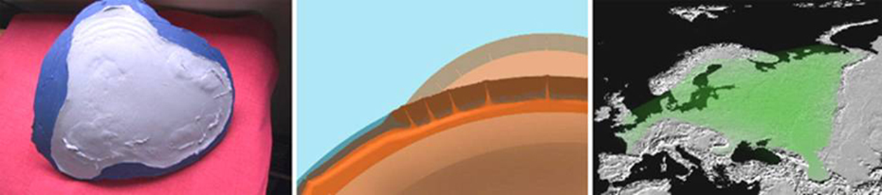
On this experimental model I obtained only a single row of cracks. This was a
limitation of the experiment. In real-world geological history
these crevice molds would have gotten filled with hot materials at the same
time as they were torn open. Gradually they would have cooled and toughened.
This means that parallel rows of cracks would have been torn open and filled
next to them.
A marginal detail of my
experiment deserves to be mentioned. I have put forth every effort to lay down
an even putty surface onto the experimental balloon. Only at one place did I
allow a thin fold to form underneath, intentionally, running ninety degrees
against the direction along which I expected flanging to occur. I wanted to see
how such an adverse wrinkle would behave.
No crack was torn across
this test fold. But small perpendicular fissures have begun to form. These
fissures are not spaced at crossings, exactly opposite one another; rather, the
crust at either side of the test fold simply tore wherever tension from
expansion friction exceeded the putty’s cohesion factor. We have here a clear
case of offset faults, such as have been discovered along rifts and cracks in
the oceans. Such offset transform faults are being created because the
lithosphere is being stretched in all directions at once -- by all-around Earth
expansion. All the while, cracks break open at random, wherever and whenever
tension is sufficient. Because the oceanic lithosphere is thinner, rifts and transform
faults are breaking through the surface more easily than on continents.
Another experiment has
yielded unexpected results. My quantity of putty was too dry, and it sat and
slid upon the rubber surface as though expansion-friction (Relative Expansion
Flow) did not matter. The experiment seemed unworthy of a plaster cast. But
scientific habit prevailed, and behold! I got a continent covered with low “granite”
domes. I recognized this landscape immediately, because I have seen it in
Africa.
From Baby Mountains to Grand-old Peaks
Evidence for a rebuttal of
subduction-oriented Plate-tectonics stared me right in the face on several
occasions during that same field trip in Colorado. Thirty years earlier, while
crossing the mountain ranges between North America’s Mojave Desert and the
Great Basin, I contemplated their origin as hot intrusions from below. By the
time I got to California I suspected the presence of Baby Rocky Mountains under
the bulge of the eastern Colorado High Plain.
Alongside the Colorado
Highway 10 I saw my first Baby Rocky Mountains, eleven miles
northeast of Walsenburg, and another outcropping near the twenty-eighth
milepost along that same road. These igneous tips of subterranean mountain
ranges are known today as Rattlesnake Buttes and are barely protruding now.
Next to them still extend wide stretches of old overhead layers and sediment
that presently are being eroded at a faster rate than these young peaks.
Sediments are being carried
eastward by rivers, and they contribute to weighing down the Central Plains
just a little more. The cycle exerts a little more pressure westward, deep
under Colorado, and these low mountain tips are destined to rise. In time they will be more exposed and erosion will scrub them
for better viewing.
Nevertheless, the primary
engine for mountain formation and uplift is not climatic erosion. Earth
expansion is that engine. The energy and material for mountain formation, and
for uplift, comes from beneath the lithosphere. There the mountains are
pre-formed. Because the Planet expands, continental surfaces necessarily must
flatten. This means that the mid-regions of continents must sag and adjust to
the new curvature. And by so settling they produce large central plains that
some geologists call “cratons.”
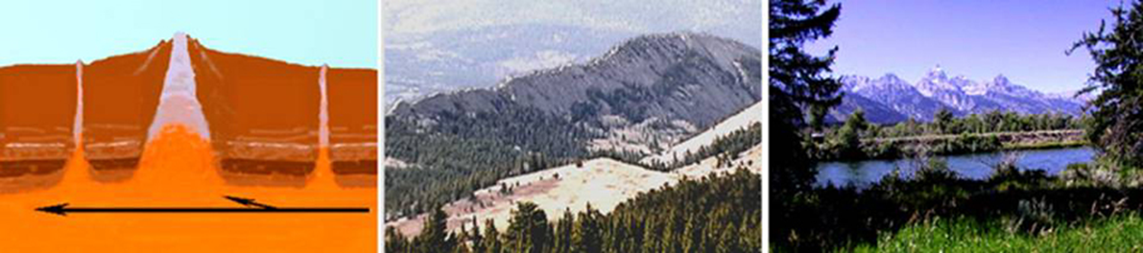
Underneath, where mantle and
lithosphere share a viscous semi-liquid cushion between themselves, surplus
magma is being squeezed sideways and outward from under the middle of the
continental crust. Creeping outward from under the flattening continental shield,
magma pressure can cause outlying plains to bulge upward and become “high
plains.” Then along that bulge, the brittle lithosphere may fail to contain the
increasing pressure from underneath. Anciently pre-molded, jagged mountain
ridges gradually break forth and rise. They are being uplifted hydraulically
from below, pushed by their own youthfully hot, sluggishly creeping posterity.
The processes of magma
injection from beneath, and uplift for exposure to erosion, are displayed well
in Colorado. These dykes are evidence that Earth expansion has continuously
been widening and filling some cracks in the crust from below.
After having seen the lowest
Rocky Mountains, and having observed subsequent smaller intrusions among the
larger ones, we are ready to contemplate the Planet’s highest Alpine peaks. The
collaged geology of these mountain ranges has frequently been noted by
geologists. But their extraordinary variety need not overly surprise us -- considering
how they were formed. Multiple cracks along the underside of the lithosphere
were not all torn open at the same time, or squeezed full with the same magma
melt each time.
So, before we allow Alpine
reality to overwhelm us, we should bear in mind that the age sequences in
sedimentary and igneous strata generally are different. Sedimentary layers, at
the surface of the lithosphere, are deposited on top of one another. Unless
they get overturned by severe tectonic upheaval, bottom layers are oldest and
top layers are youngest. In addition, they are unevenly distributed on the
surface of the Planet.
At the underside of the
lithosphere, “erosion” and “deposition” do happen upside down. Hot igneous
strata are pasted to the bottom of the lithosphere, and are cooled from top
downward as the crust thickens. Younger magmas carry with themselves
sedimentary and metamorphosed scrapings from the lithosphere overhead as well
as from the mantle below. Together these materials may end up either intruded
into fresh crevices, or layered underneath older rock which they help uplift
hydraulically. Hydraulic fluid and molten rock, in this case, are the same
substance.
Many Earth-science texts
give the impression as though Alpine mountains have risen, and then been given
all their characteristic shapes by climate and erosion. Most of the high Alpine
mountains are covered nowadays with snow and ice. On that account, glaciers are
given most of the credit for having fashioned them. And indeed, the
contributions of glaciers to Alpine cosmetics are extensive. But seriously! Did
these long mountain ranges get their crests, or did the Matterhorn obtain its
shape, only as a result of weather and glaciations? Did water carve all the
wedge-shaped valleys between the Alpine crests from a solid igneous block, all
the way to the creek below? Or were the igneous crests approximately pre-molded
before they were uplifted? I am inclined to accept the latter. It seems highly
unlikely that granite domes in Zimbabwe, even if they were uplifted in the
climate of Greenland, would ever be worn down to jagged Alpine peaks and
ridges.
It looks as though many
Alpine peaks in the world have been molded during the late Precambrian and
early Cambrian periods. Here is a map that sketches Precambrian mobile belts
(It is based on a projection by Professor Harold Levin, The Earth Through Time,
1988). Accordingly, expansion must have been underway already 500 million years
ago -- thus long before the first oceans began to crack open. These jagged high
peaks were uplifted to pierce forth at many places on the Planet -- such as in
the Alps, the Himalayas, and in the Rocky Mountains of North America.
Since Jurassic times, the
continents have extended their crusts by way of adding stripes of ocean floor.
Along the oceanic spreading-rifts we therefore find another generation of
mobile mountain belts, generated and uplifted by the same processes of Tensile
Folding, Flanging, and relative Expansion Friction.
Relative Expansion-friction,
or Expansion-flow, is caused by expansion movement in the mantle. Relative to
the continental crust that lies overhead, Expansion-flow increases its speed
outward from the middle of a continent. It grows a half-ocean along the
continental edge. The outer edge of the young surrounding crust rolls upward as
a half-anticline. In this manner the puckered “lips”
of tectonic plates touch lightly, uplifted by hot magma. Their light “kiss”
surrounds the whole Earth.
If a crack from down below
is torn all the way up through the lithosphere, the intrusive magma may erupt
and a lava flow may result at the surface. Examples of such massive flows are
the Deccan Traps in India and the Idaho-Oregon-Washington Flow in North
America. If only a small orifice is opened, perhaps at a weak spot of
intersecting faults, we may see a volcano. However, the brittle lithosphere
frequently collapses upon and pinches these wedge-shaped intrusions, and
prevents their eruption. In any case, upward in the lithosphere the intrusive
magma tends to coagulate and cool.
Strong earthquakes are rare
in the middle of sagging continental shields or “cratons.” But they do happen
when a brittle section of the continental dome collapses to adjust to the
expanding and flattening mantle curvature. Such inland earthquakes, when they
are contained in a craton, frequently create over- and under-thrusts that in
time may extend to tens of kilometers. Petroleum engineers in the American
Midwest frequently find themselves drilling through the same stratum twice.
Expansion tectonics can explain such duplicate stratification rather easily.
In my 1999 booklet, Planet
Earth Expanding and the Eocene Tectonic Event, I have explained the 1964
earthquake in Alaska, and the New Madrid Fault earthquakes along the
Mississippi River, 1811-1812, as examples where sections of continental domes
have collapsed. The Alaska movement slipped the continental edge outward onto
its lower oceanic plate extension. The New Madrid Fault by the Mississippi
River has produced over- and under-thrusting of rock strata. Interlocking
layers raised the land surface and stopped the flow of the Mississippi River
for a time. The large continental area that surrounds the New Madrid Fault, in
addition to its sheer size, is also reinforced by mountain ranges that run
along the continent’s periphery and prevent sea-side over-thrusting of the Alaska
variety.
Part One of this
presentation can now be summed up in form of a small riddle: In their first
manifestation during tectonic evolution, how could a mountain range and an
ocean be distinguished from one another? The Answer is: They could in the beginning
not be distinguished from one another, because both originated as similar
cracks along the underside of the Earth-crust. Their later differences must be
explained in terms of differential expansion rates in the mantle, and in
relation to regional physical characteristics inherent in the crust.
Part Two
Spreading Oceans and Growing
Continents
Makers of paleo-globes
usually have, for the sake of simplicity, preferred to work with a “budget of
available areas.” However, I personally have come to the conclusion that a
“budget of continually adjusting tensions” is of equal importance. I therefore
like to begin the second half of my presentation, concerning the oceans and
continents, with an emphasis placed on continental cohesion down in the asthenosphere.
After an overview on directional tensions has been provided -- illustrated in
the shape of three straps that during the Eocene were reduced to a simple belt
-- the “budget of available areas” will display itself.
Three Straps and a Belt
When the crust of our planet
began to tear open seriously during the Jurassic, there appeared cracks that
later widened to become the Pacific, Atlantic, and Indic oceans. These first
cracks could be found within a wide band that wound around the Earth along the
equator. This may mean that our planet has for a long time been an oblate
sphere, flattened at its poles, and that the largest early expansion cracks
therefore did burst open along an equator. The larger cracks appeared somewhat
below the middle, and they extended themselves toward the present south. In the
south they united -- and together they widened there into the oceanic spread of
the southern hemisphere.
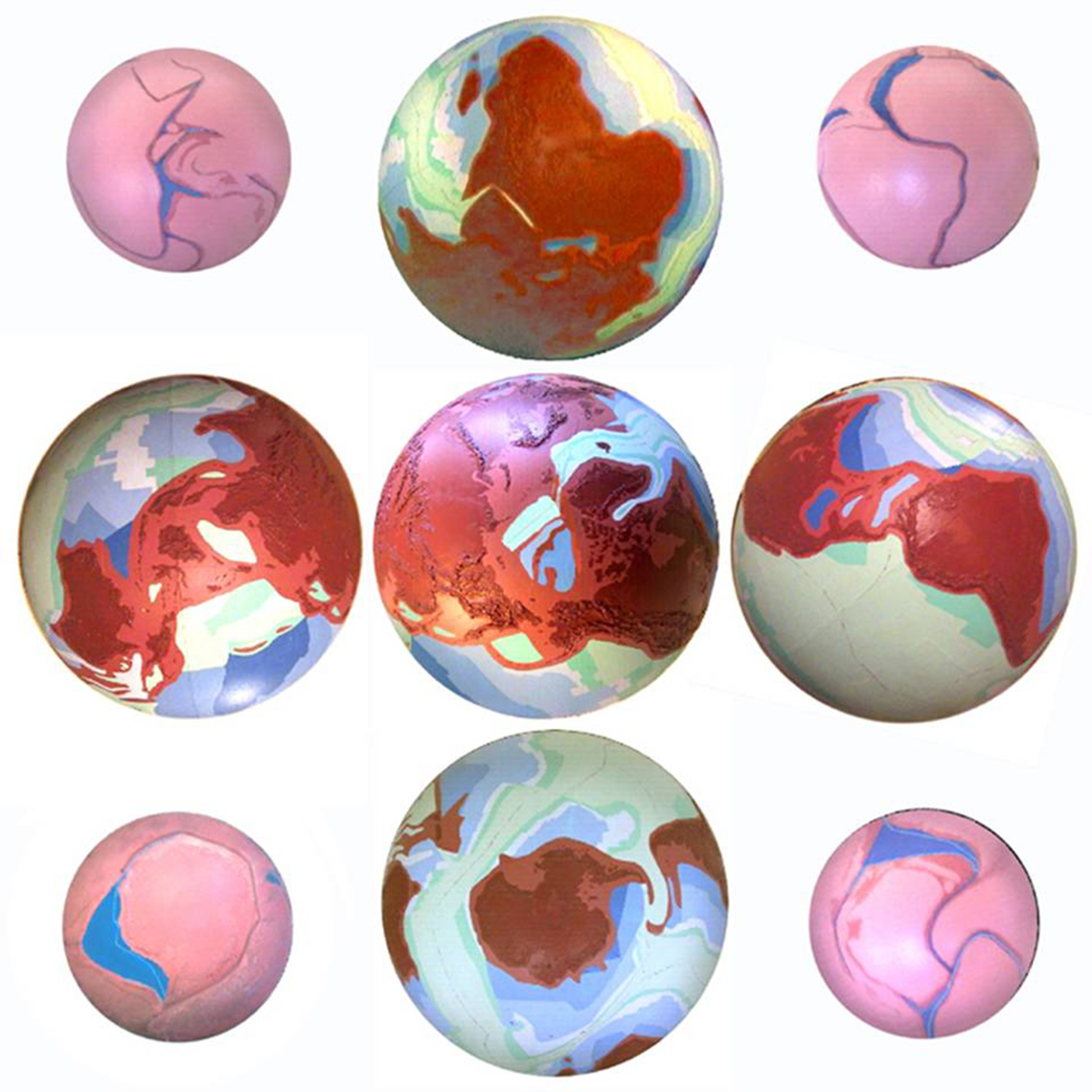
Large
hemispheres showing present continental cohesion in the north and separation in
the south.
Smaller Jurassic hemispheres showing the beginnings of our deep oceans.
When our oceans were still
young and existing by themselves -- that is, during Jurassic times before
Africa, South-America and Australia were severed from each other -- the cracked-open
crust of our expanding planet still consisted of three bands or „straps“ that remained fastened together in the north and in
the south. All three continental bands were significantly stretched apart,
already during Jurassic times. Large stretch-zones came into being along the
Mediterranean, in Middle America, and in Austral-Asia. An additional area of
severe stretching can also be found in the Arctic. At two opposite forks which roughly correspond to our present poles, all
three bands remained connected into the Lower Cretaceous. One of the
continental straps ran from the Arctic over North-America to South-America; the
next ran from the Arctic over Eurasia toward Australia, and the third from the
Arctic over Eurasia to Africa. In the north all three
of these continental bands remained somewhat connected with one another, but in
the south they have broken apart. Today these three straps, the remains of
continental bands, can still be seen dangling downward along the southern
hemisphere.
Because the continental
straps broke first in the south, and because their breaking has reduced
expansion stress in other areas, there was no immediate need for them to also
tear apart in the north. The tip of South America had been seated in the Bight
of Australia until the Eocene. These two southern continents separated
approximately 43 million years ago, when the Earth-surrounding belt of four
continents broke in the south.
During the Cretaceous the
“Africa” strap broke off along the toe of South America. This first breakaway
of a continental strap, between Africa and South-America later during the Lower
Cretaceous, is marked by two events. Firstly, the Cape of Africa departed from
the toe of South-America, and secondly, expansion in the Black and
Eastern-Mediterranean seas came to an end. From this point
onward Africa was no longer pulled southward. It may be assumed that, as a
result of the relaxed tension caused by the severance, the Mediterranean Sea
shrunk a little, and that tensions were relaxed even into southern Europe. This
loosening of tension stimulated the uplift of the Alps -- however, not through
a collision or under-thrusting by Africa, but through magma that could be
pressed under the relaxed area from the north.
The remaining two straps -- that
is, the two Americas together with Asia down to Australia -- remained fastened
to each other all the way into the Eocene. Like a belt these four continents
surrounded Antarctica and the Pacific, and thereby the entire expanding planet.
The tension along the simple belt, which wound from South-America over
North-America, Asia, Australia and back to South-America, was increased until
the Eocene. South-America thereby was stretched lengthwise by Australia until
the two continents finally broke apart. Today, almost forty-three million years
later, South-America is still 400 kilometers longer than it needed to be
earlier in its union with Africa.
It is noteworthy that the
rupture between Australia and South-America, during the Eocene, merely
represents a continuation of the earlier break during the Cretaceous. The crack
continued at the same place. This means that the two ruptures, together, must
have torn open a very deep gash that was destined to widen the entire Southern
Ocean. This crack has agitated the asthenosphere apparently down into the
mantle.
Obviously, the talk about a
“crack,” in this context, pertains only to a “superficial” surface perspective.
The deeply torn gash can also be valued positively, as locally amplified growth
in the mantle, caused by Earth-expansion. In addition, this entire torn area
became a new home to the firstborn continent of the Planet -- round Antarctica, which leaned into the widening space while
slowly turning.
While in earlier days we
constructed our paleo-globes in hope of improving our continental outlines with
better continental shelf estimates, we now have vastly improved topographical
maps of all the ocean floors. Since 1988 we also have the UNESCO Geological
World Atlas, with ocean floor maps based on magnetically embedded stripes and
reversals. While not everything on these maps is perfect and free of risky
projections, some of the stripes have been drilled into, dredged, and dated. We
now have sequential isochrons -- a series of steps
extending from a zero-ocean globe in the Jurassic, some 180 million years ago,
to the size of the present oceans. This situation is a scientific illustrator’s
dream that has become reality.
With the help of isochrone-maps
it is now possible, theoretically, to take any ocean and reduce it to its
Jurassic size. This method works fine all across the Atlantic. But as soon as
one attempts to reduce any of the other oceans, one gets stuck in the Oligocene
or Eocene. If one cannot go backward one must try to move forward. But move
forward from where? All earlier starting positions are necessarily
hypothetical. If one reassembles the continents on a globe of a little more
than half its present diameter, and if one estimates somewhat reasonably
certain areas of stretch, then all the continents and their shelves can be
accommodated.
The Eocene Event in the Indic Ocean
After some hesitation, in
1979, I have concluded that the cape of South-America must have come out of the
Bight of Australia. This implies that the Continent of Antarctica must be an
intruder in its present realm.
The Indic Ocean contains an
important key for deciphering the Eocene puzzle. Nevertheless, before this key
can even be recognized, Wegener’s impossibility concerning the wanderings of
India must be cleared from our path. While formerly India was closer to Arabia
and Africa than it is now, surely it never was farther away from Asia than it
is now. According to the new isochron-maps, nothing
spectacular happened in the Indic Ocean during the Lower Cretaceous. However,
during the Upper Cretaceous the large island of Madagascar slid southward -- or
shall we rather say it was invited by a tentative vacuum down south. This
tentative vacuum came into being because the oceans widened in the south much
faster than in the north. The small Madagascar plate could slide southward
because continental plates, generally, abide in pre-cut readiness for sliding
along their edges -- along the soft oceanic spreading rifts.
The rifts of severance that
ran along both sides of Madagascar were aligned in the same general direction where
today one still finds, in the west, the Great African Rift, and where in the
east we still see the Ninety-east Ridge scar. It is possible that the severance
of Africa from the toe of South-America has contributed a first jolt for the
movement of this island. With Africa moving northward after its severance, all
that Madagascar needed to do is to remain stationary, and in terms of relative
movement it would implicitly be on its way south. As a result of the island’s
movement, some Jurassic floors were probably obliterated along their edges.
Obviously, in this
discussion all references to the directions -- east, west, north, or south -- are
to be understood in relation to the present globe. I do not wish to say much
about the location of the poles or the equator during the earlier epochs.
The Paleocene and Eocene
floors in the Indic show that the entire continental mass of Austral-Asia was
bent eastward and away from the Ninety-East Ridge. The Eocene triangle, in the
northeastern corner of the Indic, leaves no room for another explanation.
According to tephro-chronology, this eastward bending
might have happened some 42.7 million years ago. This date of 42.7 million
years ago has been assigned by tephro-chronology to a
huge tectonic upheaval along the Ninety-East Ridge (see Jonathan Dehn,
http://www.aist.go.jp/GSJ/~jdehn/research/diss.htm). The
continental edge that left the Ninety-East-Ridge scar -- the longest straight
line on the globe -- could initially only have been pulled straight by a
north-south tension. Then, while the Austral-Asian continental unit was bent
eastward, the west/east Paleocene spreading rift provided the soft edge along
which all the older southern floors, up to the Paleocene, could slide east and
northward together. On a sketch-map we can return some of these to their former
places.
The angular slabs from the
Cretaceous appear to be broken and pushed into one another -- too much to be
completely sorted out at this very moment. We shall keep this condition in mind
and simply return Australia to its earlier approximate position. From the other
side of the globe we bring home the tip of South-America into the Bight of
Australia. Thereby we have reconstructed the belt of four continents, which
spanned the Earth.
The round Pacific was expanded
over the course of time, to such a degree that the belt that consisted of four
continents -- Australia, Asia, North-America, and South-America -- was
stretched into a great circle around the Planet. In this hopelessly stretched
condition it was only a matter of time before that belt would break. The
worldwide Eocene event was triggered when, finally, Australia and South-America
snapped away from each other.
This flat map is ill suited
to illustrate the dynamic of an expanding sphere. While we now turn to an
approximate Paleocene globe, we are enabled to observe the Eocene event from
the perspective of the Indic Ocean. When Australia let go the tip of South
America, the Eocene event in the Indic was fully under way. The process
continued to the present globe more or less as a tranquil expansion. Please
observe the loosening of tension and the pull-back of East-Asia, which resulted
from the severance that happened in the south. The consequences in East Asia
shall be the subject matter of our next section.
While I now display the
evolution of the Indic, in the time-span of one minute, I will only name the
epochs: Jurassic, Lower Cretaceous, Upper Cretaceous, Paleocene, Eocene, and
Oligocene onward to the present globe.
The Eocene Event along East Asia’s Marginal Seas
Now we bring our camera into
the northern Pacific and look westward -- to obtain a wide-angle view of the
marginal seas of East Asia, ranging from the Philippine Sea all the way to the
Bering Sea up north. This entire area was modified by the Eocene event. All
East-Asian marginal seas were pulled open during the Eocene.
The Philippine Sea began to
enlarge already during the Paleocene. A sliver of Paleocene sea floor appeared
behind the loop that was destined to become the Marianas archipelago. During
the Eocene, this Paleocene sliver in the Philippine Sea was cut into half by a
rift that slanted north-westward.
The great retreat of the
Asian mainland was triggered by the break in the global belt of four
continents. When Australia broke away from the tip of South-America, eastern
Asia was liberated from the Earth-surrounding tension which, since the
Jurassic, had been continuously increased.
The continental mass of Asia relaxed and withdrew toward the Northwest.
Eastern Asia left behind a band of island arcs that extends from the
Philippines all the way to Alaska.
On the Asian mainland changes have occurred as well. When one observes the general
topography of Asia, it becomes obvious that the many mountain ranges there
cannot very easily be explained as being merely peripheral phenomena along the
Siberian craton. It appears as though there also has occurred a loosening of
tension, from the southeast. During the “loosening,” magma that was required to
uplift these mountain ranges came, nevertheless, from the larger dome of the
continent -- and from under the Moho. A small craton, the Tarim
Basin, was compressed and pushed downward while, next to it, the Himalayas were
uplifted to the highest mountain region on the globe. As a next trough, farther
south, appear the Indus and Ganges plains. These lie before the Himalayas after
the fashion in which, on a smaller scale, the Po valley lies in front of the
Alps.
A Round Continent
When mantle-expansion is to
peal from the crust of a planet a first continent, what might be its shape?
About a quarter of a century ago I have concluded that it could be round. Then, in 1998 I undertook a series of
tear-experiments that involved the breaking of balloons.
Here are some samples of
typical first patches that were obtained during these tear-experiments. In
order to slow down the tearing of the balloon skins, I have inserted a second
skin as a lining -- so that outward expansion pressure might be transformed
into horizontal tension along the surface. Later I have slipped a transparent
third skin over the top, to capture the results between two layers. In general,
the results indicate that it is reasonable to expect from the skin of an
expanding sphere a rounded patch -- and that a teardrop-shaped balloon tends to
produce a more ellipsoid patch.
Jurassic Australia, and
Antarctica, could not have been joined in the manner in which most proponents
of Earth-expansion, in the tailwind of Wegener, still are thinking. The round
of Antarctica is larger than the Bight of Australia and could therefore not
have come out of the latter. In addition, there were during the Paleocene and
Eocene no agents in the vicinity that, with any kind of leverage, could have
torn the two apart. Continents were not somehow born as freely wandering vagabonds,
as Wegener imagined them -- or as some dedicated believers in popular Plate
Tectonics still like to move them about in their Pangaea-puzzles. It is rather
the case, that upon the expanding Earth, already in Precambrian times, the rims
of sleeping continents were weakened along the underside of the Planet’s crust.
In order to obtain horizontal tearing upon the expanding sphere, viscously
coherent substrata had to be defeated. To these viscous strata apply the
designations “Asthenosphere” and “Mohorovičić
discontinuity” (“Moho” in brief).
From obtaining a first
rounded continent it is but a small step to visualize the expanding cavity from
which Antarctica might have been peeled. As the round of the Pacific Ocean
proceeded to tear, it continually reset the global tension pattern in the
viscous layer underneath the crust -- namely the fields of stress along which
the other oceans would be torn. Each fresh tearing in the crust would affect
the direction of tearing elsewhere. While over time Antarctica was torn free in
the form of a “9,” the Atlantic was torn southward in the form of a slender
“S.” The Indic Ocean was torn northward along eastern Africa, a path which for
a while looked like a straight “I” (and later like a “λ”). Of course, all
directions mentioned in this lecture are approximate and correspond to a
present-day globe.
The Atlantic and the Indic
have torn for themselves, from the south, some large V-shaped peninsulas up
north -- Greenland and India. Even the small Red Sea has torn up north the
triangular Sinai Peninsula. Among the three great equatorial oceans, only the
Pacific is without this triangular feature up north -- because this ocean has
been torn from within itself, and round-like.
By now I have come to regard
the Pacific and the Antarctic oceans as a single entity. Taken as one, this
largest of the oceans has been expanding mostly in the southern hemisphere -- widening
from there subsequently the Atlantic and the Indic. Inasmuch as the
Pacific-Antarctic Ocean has peeled out for itself no angular feature in the
north, it nevertheless has within itself three V-shaped continents. Originally
the capes of Africa and South-America, and the “tail” of Antarctica, were all
sliced in the same direction -- toward the Bight of Australia. Six V-shapes,
all pointing in the same direction, together hint at some source of unified
tension. This source, I propose, has been the global cohesion among three continental “straps” and the subsequent “belt” of four
continents.
Reading the Isochrons
Since the discovery of
magnetic stripes and the production of chronological ocean maps, the
age-boundary, which divides the round Pacific right down the middle, has become
our primary puzzle. The western half is older and contains floors from the
Jurassic to the Paleocene. The eastern half is younger and features floors from
the Eocene to the present. The new formulation of the riddle is therefore:
Where was the Pacific spreading rift since the Upper Jurassic -- from 180 to 43
million years ago? Some scientists have suggested that there may not have been
an early spreading rift. But if this is the case, then the Pacific contradicts
everything that we have learned about symmetric spreading in the other oceans.
While a spreading rift in the round-like expanding
Pacific could not always be straight and constant, it nevertheless seems that a
dominant spreading rift has persisted there over time -- all the way to the
point when an entire plate was severed. Earlier, the direction of the older
spreading rift had to circumvent the round of the continent that got torn from
the Pacific womb. This means, the direction of tearing had to keep changing.
Indeed, spreading rifts in the Pacific have proven to be as ephemeral as the
sea-faring Henry William Menard has always suspected them to be.
Since the Eocene the central
spreading rift of the Pacific has radically changed its location. From Mexico southward it has gradually combined itself with a
coastal rift that ran along South-America. The two rifts could unite only after
an entire plate had slid southward -- similar to the movement of Madagascar in
the Indic, two epochs earlier. The eastern half of the old Pacific moved
southward as a tectonic plate in which the continent Antarctica lay embedded.
Like other continents, so
also Antarctica has added alongside itself certain crusts of ocean floor. Its
plate grew toward the middle of the old Pacific. Moreover, like all other
continents that slept in the early Jurassic crust, the continent was pre-carved
several hundred million years earlier through tensile folding and
expansion-friction. In the east the plate remained
embraced, for a long time, by the two American continents. South-America was
still held together with Australia by the viscous asthenosphere -- as was the
entire belt of four continents that was wound around the Earth.
What empirical data are
there, that permit us to derive Antarctica from the space of the Pacific?
First: The oldest Jurassic
patch of ocean floor one finds in the north-western Pacific. A Jurassic band,
of matching length, runs also alongside Antarctica. Both patches lie inclined
in a manner that enables us to derive Antarctica by way of beginning there.
According to these circumstances, the two Jurassic portions would have drifted
apart because of ocean-spreading -- specifically through the continuation of
the Jurassic rift during the Cretaceous.
Second: When the shape of
Antarctica is contemplated, then one discovers that it not only fits into the
round Pacific, but likewise into the conspicuously active Ring of Fire. The
contour of the Pacific, and the violence outlined in the Fire-Ring, are
associated by their shapes. Both have the shape of a “9” -- as has the
continent Antarctica. The irregular appearance of Austral-Asia, which
corresponds to the upward curve in the figure “9,” need from an evolutionary
point of view not necessarily be judged as an irregularity. This region is
presently under less stress than it had been during the Cretaceous or the
Paleocene. To this consideration may be added the fact that Antarctica, to this
day, has not managed to move outside its Pacific home region -- this means,
across the threshold line between Australia and South-America.
Third: In addition to the
contour of the Pacific, and of the Ring of Fire, one can today contemplate the
finger-print of expansion also on hand of magnetically established isochrons. Successive isochrons
provide us, regularly since the Jurassic, with the “9”-shaped contour of
Antarctica in its proper inclination. They help us trace the sequence of
expansion stripes up to the present. The Ring of Fire still surrounds the
original scar -- namely, the wound of the womb from which, in the course of
approximately 140 million years, Antarctica has been severed and separated.
Fourth: During the early
Eocene, South-America has loosened its embrace around the teardrop shape of the
Antarctic plate. The Eocene ocean floors, which were formed as a result of this
loosening, along the coastline of the Americas, are clearly indicated on the isochron-map. These Eocene patches are difficult to explain
without the departure of the teardrop-shaped Antarctic plate. They are too
short to be simply counterparts for the long Eocene band that, on the other
side of the spreading rift, runs down the middle of the ocean. Along the
north-western coast of North-America the Antarctic plate sprung loose somewhat
later, and along its southward path some of the earlier Eocene floors were
erased. Along the middle of the Pacific the floors of the early Eocene, the
Paleocene, and the Upper Cretaceous, then began to lean and to broaden
eastward.
The epochal stripes of these
floors widened and leaned eastward as if the ocean were a dish of gelatin. For
a considerable length of time no spreading rift was necessary in the east -- until
Earth-expansion caught up with the hardening process of the crust, and until
the “gelatin” had found its new tectonic balance. Or, to explain the same
process without using the metaphor: In the course of 43 million years the
eastern Pacific area necessarily contracted at first, and when thereafter
global Expansion caught up with its soft areas, it developed a fresh compromise
spreading rift.
A Rare Continental Collision
There are traces of a
continental collision in which Antarctica had gotten involved. From the chaotic
topography at the floor of the Scotia Sea it appears as though Antarctica has
entered there at a reckless speed, coming from elsewhere. It collided and took
out a significant bite from the cape of South-America. The recent departure of
Australia gave South-America not enough time to surround its coastline with
fresh crust of ocean floor -- that might have cushioned the collision.
Seven years ago (in 1996) when I first animated this collision, I
associated the route of the turning plate directly with the collision that
followed. Because the continent needed to turn into the Southern Ocean
counter-clockwise, in order to attain its subsequent inclination, it seemed as
though South-America had been “bitten” during that process. During my final
revision of that video I had in my hands the decisive NOAA map, of 1994, but my
animations had all been finished earlier. Observing now more precisely, one can
see that the collision did not happen because Antarctica was turning into that
space, but it happened as a direct impact from the south-west. Antarctica had
come from the same direction in which it now is retreating.
With great force it has scooped up the Sandwich archipelago bulge. All
the way to the Islas Orcadas Rise has the crust been
scooped -- which means, across the entire width of the Cretaceous and Paleocene
floors in the western Atlantic. When the Antarctic plate retreated, it jarred a
deep trench behind the Sandwich bulge, and in front it tore open an active
spreading rift. In addition, the entire width of South-America’s toe was broken
through, northward. A line of displacement can also be seen along the entire
northern edge of the toe.
If Antarctica has not caused
this collision by its own twisting motion, which mobile agency should then be
blamed for this continental “accident”? The time has come that I must speak
more precisely about events that happened between Australia and Antarctica. We
are faced with a dating-problem on the Pacific and Antarctic isochron maps. Already in 1998, in the course of a
semipublic e-mail debate, have I gotten into an argument about this matter with
James Maxlow. In my 1999 booklet
I have tried to furnish the disputed places on my Pacific map with polite
English question-marks. Nevertheless, my present lecture for the Theuern Colloquium was first written in German -- and in
German these question-marks signify an emphatic “Impossible!”
During the Eocene event Australia has separated from South-America and has snapped
northward behind ocean-floors from the Cretaceous. Ricocheting then, it leaned
east toward the void that had been left by the departing Antarctic plate.
Australia thereby pressed Cretaceous floors against the bare back of Antarctica
and pushed everything together against the cape of South-America. The disputed
epochal stripes, which on the map are colored Paleocene and Eocene, can
therefore not be older than Oligocene. The Scotia Sea was opened again, with
the same movement, during the Oligocene.
Epochal stripes in the
eastern Pacific can be precisely dated only after the movements of Australia
and Antarctica have been ascertained. Moreover, along the path of a continent
that moved from the vicinity of one magnetic pole to the other, surely some
geographical lines were being disfigured in the process -- possibly even the
magnetic energy lines themselves. Corresponding magnetic “reversals,” on our isochron maps, can therefore not be dated yet with great
certainty in these areas.
Ricocheting away from the
edge of Antarctica, Australia then moved westward. In its wake
it left New Zealand, along with the Tonga Ridge and Trench. The topographical
map of Bruce Heezen shows the entire tail that
Australia has dragged. In the west, Australia has thereby also tightened the
land-swirl around Celebes.
Antarctica Animations
To solve the Pacific puzzle,
I will animate the story about the birth and liberation of Antarctica, twice
from the Jurassic to the present. If the movements of Antarctica should appear
too fast, for the Eocene, then let us consider that one second in this
animation represents, nevertheless, three million years.
During the first round we focus our camera on Antarctica itself: Jurassic,
Lower Cretaceous, Upper Cretaceous, Paleocene, Eocene, and Oligocene up to the
present.
It must have become obvious
by now, that my animation technique is not quite up to the task. Instead of
cracks I can only show lines by means of extreme stretching. In order to avoid
having my colors and continental patches flow into one another during simulated
movement, I must maintain unseemly distances between them. By contrast upon the
real Earth, any relative movement among the tectonic plates does happen along
real cracks and always in close conformity with the surrounding plates -- almost
with the flexibility of a birthing process. Only the wide
open gaps in the lithosphere, produced by Earth expansion, have been
able to persuade a few of our continents to travel a little-ways.
For the second round we
focus on the area between Australia and South-America, where Antarctica has
arrived during the Eocene: Jurassic, Lower Cretaceous, Upper Cretaceous,
Paleocene, Eocene, and Oligocene up to the present.
The flexibility in the total
crust of the Planet, for facilitating the “birth” of a continent, is to be
sought mostly along the thinner floors of the oceans. Here and there around the
sphere, these floors can be compressed and stretched wherever required by
greater forces. For our research with satellites this means that unless
measurements of movement can be obtained contemporaneously around the entire
globe, the results will not be of much help to us.
Regardless of my overly
loose animations, scientists in the field of paleontology may take note of my
“near-contact” hints -- between Australia, South America, and Antarctica -- and
consider these as potential temporary land bridges for certain species of
animals.
Reverberations in two Americas and the Atlantic
As a result of the Eocene
event the continents of the Earth suddenly lost the cohesiveness that formerly
was maintained by tension along the global “belt” of continents. This new
instability affected especially the continents in the southern hemisphere. The
liberation of South-America from the global belt has bent Middle America toward
the northeast -- along the entire width from Panama to the West Indies.
Meanwhile, the Atlantic spreading rift of the Eocene has pinched off a small
area of Paleocene ocean-floor. It has left it lay in the Mid-Atlantic, along
the Middle American latitudes.
South-America has moved
sufficiently toward the northeast, and has pushed Middle-American ocean floors
against the southeastern corner of North-America. Thereby it has pushed this
northern continent westward, a little-ways over what used to be the
Antarctic/North-American rift of separation. The Gulf of California and the San
Andreas Fault today mark this line, as it has broken through at the surface.
In order to conclude this
treatise, I need only to show yet the expansion process in the Atlantic. This
ocean explains itself: Jurassic, Lower Cretaceous, Upper Cretaceous, Paleocene,
Eocene, and Oligocene up to the present.
Bibliography
Alvarez, Luis W. T. Rex and the Crater of Doom, Princeton:
Princeton University Press, 1997.
Bevis, Michael and Barton Payne. “A New Palaeozoic
Reconstruction of Antarctica, Australia, and South America,” in Carey, S. W.
Expanding Earth Symposium, Sydney, 1981, pages 207-213.
Carey, S. Warren. Theories of the Earth and the Universe: A
History of Dogma in the Earth Sciences. Stanford: Stanford University Press,
1988.
_____. ed. The Expanding Earth, a Symposium. Sydney: Earth
Resources Foundation, 1981.
Choubert, G. and Faure-Muret,
Geological World Atlas. Paris: UNESCO, 1976-1988.
Coleman, Robert G.
Geologic Evolution of the Red Sea, Oxford: Oxford Monographs on Geology
and Geophysics, 1997.
Jonathan Dehn
www.aist.go.jp/GSJ/~jdehn/research/diss.htm.
Gottfried, Rudolf. „The Importance of Quantitative
Inspections for the Understanding of the Earth’s Origin,“
in New Concepts in Global Tectonics 2002, La Junta, Colorado, pages 100 – 117.
Grand, Stephen P. and Rob C. Van der Hilst,
and Sri Widiyantoro, “Global Seismic Tomography, a
Snapshot of Convection in the Earth,” in GSA Today, April 1997.
Hoshino, Michihei. The Expanding
Earth: Evidence, Causes, and Effects. Tokyo: Tokai University Press, 1998.
Hsü, Kenneth J. Challenger at Sea: a Ship that Revolutionized Earth Science. Princeton:
Princeton University Press, 1992.
Jacob, Karl-Heinz. “Self-organization of Mineral Frabrics during Lab Experiments -- a possible Key for
Better Understanding of Mountain-Forming Processes?” in New Concepts in Global
Tectonics 2002, La Junta, Colorado, pages 278 - 285.
Lamb, Simon and David Sington.
Earth Story, the Shaping of Our World. Princeton: Princeton University Press,
1998.
Levin, Harold L. The Earth Through Time, 1988.
Luckert, Karl W. Mother Earth Once Was a
Girl: a Scientific Theory on the Expansion of Planet
Earth. Flagstaff: The Museum of Northern Arizona Press, 1979.
_____. “A Unified Theory of Earth Expansion, Pacific
Evacuation and Orogenesis,” in Theophrastus’
Contributions to Advanced Studies in Geology, pages 61-73. Athens, Greece:
Theophrastus Publications, S.A., 1996.
_____. Expansion Tectonics, a video program. Part One: the Formation of Oceans; Part Two: the Formation of
Mountains; Part Three: Story of Discovery. VHS and PAL, 84 minutes.
Springfield, MO(update at <www.triplehood.com>),
1996.
_____. Planet Earth Expanding and the Eocene Tectonic Event.
Portland: www.triplehood.com, 1999.
Maxlow, James. Global Expansion
Tectonics: Small Earth Modelling of an Exponentially Expanding Earth. Glen
Forrest, Australia: Terrella Consultants, 1996.
Menard. H. W. The Ocean of Truth: a
Personal History of Global Tectonics. Princeton: Princeton University Press,
1986.
Meyerhoff, Arthur A. “Surge Tectonics
evolution of southeastern Asia: a geohydrodynamics
approach,” in Journal of Southeast Asian Earth Sciences. Vol. 12, No 3-4, pp.
145-247, 1995.
NASA Jet Propulsion Laboratory and National Geographic
Society. The World Satellite Map, 1998.
NOAA, GEMCO Paris, Geol. Survey Commission of Canada, Scripps
Institution of Oceanography, Univ. of Sydney, Univ. of Texas. Age of the Ocean
Floor. US Dept. of Commerce, National Geophysical Data Center, 1996.
Ocean Drilling Project www.odp.tamu.edu/sciops/LegSummaries
Parker, Sybil P. ed. Dictionary of
Earth Science. New York: McGraw-Hill, 1997.
Pflafker, George. Henry C. Berg, ed. The
Geology of Alaska (The Geology of North America, Vol. G-1). Boulder: Geological
Society of America, 1994.
Prothero, Donald R. and William A.
Berggren. Eocene-Oligocene Climatic and Biotic Evolution. Princeton: Princeton
University Press, 1992.
Scalera, Giancarlo. “Possible Relations
Among Expanding Earth, TPW, and Polar Motion,” in New Concepts in Global
Tectonics 2002, La Junta, Colorado, pages 36 – 50.
Schatzman, Evry.
Our Expanding Universe. New York: McGraw-Hill, 1992.
Suzuki, Yasumoto and Takashi Mitsunashi, Kisaburo Kodama, Yoshijiro Shinada, Seiki
Yamauchi, Atsushi Urabe, Boso Peninsula: Guidebook of
the Boso Peninsula International Symposium on
New Concepts in Global Tectonics. Tsukuba, Japan, 1998.
Tassos. Stavros. Anisotropy, Spatial and
Temporal Correlation...Earthquakes, Free-Air Gravity, and Geoid Anomalies, and
the Dominance of Uplift,” in New Concepts in Global Tectonics 2002, La Junta, Colorado, pages
247-278.
Van der Hilst, Rob C., Sri Widiyantoro, and E. R. Engdahl,
“Evidence for Deep Mantle Circulation from Global Tomography,” in Nature, vol.
386, 10 April 1997.
Vogel, Klaus. “The Expansion of the Earth, an Alternative
Model to the Plate Tectonics Theory,” in Critical Aspects of the Plate
Tectonics Theory, II, 19-34. Athens, Greece: Theophrastus Publications, S.A.,
1990.
Wegener, Alfred. John Biram transl.
The Origin of Continents and Oceans. New York: Dover Publications, 1966.
Original publication in German, 1915.
Wertenbaker, William, The Floor of the Sea, Maurice Ewing and
the Search to Understand the Earth. Boston: Little, Brown, and Co., 1974.
Yano, Takao, ed. Proceedings of International Symposium on
New Concepts in Global Tectonics, Tsukuba 1998.