The 2002 “New Concepts in Global Tectonics” Conference
(NCGT)
was held at La Junta, Colorado
Karl W. Luckert
The event at La Junta was marked by three peak
encounters.
Firstly, presenting an essay and obtaining
sincere feed-back, certainly does count as one of these peak encounters. At
this NCGT Conference it actually happened that scientists asked me to explain
my theory in detail. Thoughts shared during intensive discussions then tended
to circulate beyond the confines of single minds.
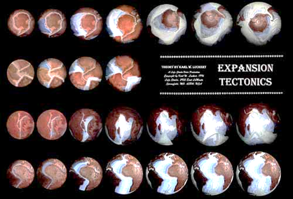
While explaining my hypothesis, it occurred to me over time, that I could do better if I had suitable illustrations of the worldwide coherence pattern of the continents. In spite of “continental drift,” a coherence pattern has persisted on our planet to this day. Illustrations enable us to contemplate inferences about past horizontal tensions in the Planet’s crust. They also show how continents tore apart and how some weaker areas between them expanded (such as has been the case in Middle America, Austral-Asia, the Arctic region, and the Mediterranean). Expansion pressure from below the crust of the Planet translates into horizontal tension between segments of the crust. I am therefore inserting, below, the images of five hemispheres which show the coherence pattern among continents and their shelves.
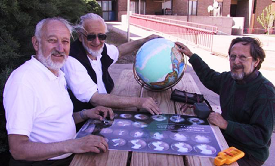
Display under
consideration on the table in the previous picture.
Second, a
renowned contributor and co-founder of Plate Tectonics, Professor Robert
Coleman from Stanford University, answered that Plate Tectonics theory has
nothing to say about the formation of “these” eastern Rocky Mountains where we
were. These mountains are being uplifted far away from any ocean where
“subduction” is believed to occur. We were in agreement. But then, proof by way
of appealing to an academic authority is of limited value in real science. It
is better to get into the habit of contemplating the geological data ourselves.
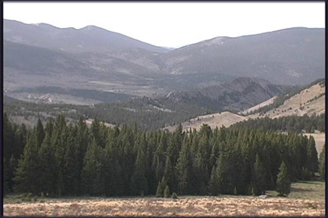
Video-frame:
Mountains in eastern Colorado.
Third, on our field trip to the mountains
I was shown for the first time something which, in line with my theory of
expansion tectonics and mountain formation, I always assumed that it exists. On
our field trip I saw some of these suspected “Baby Rockies” alongside the
Colorado Highway 10 (top picture 11-12 miles, and bottom picture 28-29 miles,
north-eastward of Walsenburg). The igneous tips of new mountain ranges can be
seen, barely protruding from the High Plains, and next to them still extend
wide and lower stretches of sedimentary layers that are presently being pierced
from below and eroded from above. Some of the sediment is being carried
eastward by rivers -- to weigh down the lower Plains some more.
I have from the outset explained
how the process of Earth expansion produces continental flanging. Because the
Planet’s surface does flatten, continental mid-regions must sag and settle down
as plains, thereby squeezing extra materials and magma sideways, underneath -- thus
from underneath the Great Plains toward the higher bulging plains to the west.
To the extent that the crust is being cracked and mended from beneath, it also
is hydraulically uplifted. Its brittle upper lithosphere is being deformed,
faulted and eroded from above. Igneous mountain ranges are uplifted by such
processes, and washed bare.
For years I have been suspecting igneous new mountain ranges under
the eastern Colorado high plain, alignments similar to those that I
have frequently crossed by driving from Arizona to California.
[A 2016 Paraphrase: “Mountain ranges happen
naturally to a planet’s brittle crust that rests upon an expanding mantle and
asthenosphere.”]
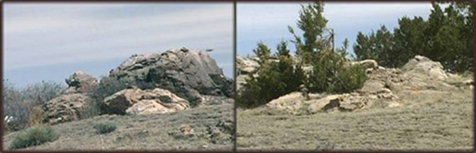
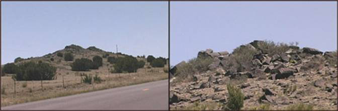
Video frames of Baby Rocky
Mountains, west of La Junta, Colorado.
“Earth
Expansion and the Eocene Tectonic Event”
NCGT
Conference 2002 at La Junta: a summary of my presentation, shortened for this
website
[I began my presentation with an
improvised Preface to fit the occasion. It went approximately like this:]
Now that we have heard from
Christian Smoot about how he sees the ocean floors, and about his doubts
regarding magnetic stripes and ocean floor dating, we can no longer be sure
whether we do, or do not have a dependable ocean floor chronology. I must
therefore alert you to the following proviso regarding my essay. If the
magnetic ocean-floor stripes cannot be dated, I will simply “bracket” all my isochrone
dates. My account regarding Earth expansion can be presented quite well without
the benefit of an absolute chronology -- that is, as long as some kind of
sequence of the magnetic stripes remains probable. I proceed under the
assumption that this is still the case. Moreover, in 1979 I came to similar
conclusions about Earth Expansion sequences, while I had only continental
contours and some topography to work with.
At the Tsukuba NCGT
conference, Japan 1998,
were two of us who presented a theory of Earth Expansion based
primarily on magnetic ocean floor stripes -- James Maxlow
of Australia and I. James
presented first, and as he spoke I watched the audience, and I saw no obvious
sign that he convinced anybody.
Then I showed a twenty-minute video animation, excerpted from my
“Expansion Tectonics.” I looked at the audience and saw no evidence that I have
convinced anyone. Afterward James and I talked among ourselves, and it also became
obvious that neither of us two was able to convince the other of his own point
of view.
After returning from Tsukuba I wrote the booklet, Planet
Earth Expanding and the Eocene Tectonic Event, which a year later I
placed on my website www.kwluckert.com which I also distributed as a free
booklet at the Annual Conference of the Geological Society of America, in
Denver.
There are, of course, some general agreements between the two of us.
(1) Both begin with a hypothesis, based on the new ocean floor chronology, that
over the past 200 million years Planet Earth has expanded roughly by the size
of its deep oceans. (2) Both agree that magnetic stripes on ocean floors are
important data which supplement what we know about topography, continental
contours, and data from ocean floor drilling. And (3) both agree on the simple
sequence in which the Atlantic Ocean appears to have spread. These three points
of agreement are completely coincidental. Neither of us had been aware of each
other’s existence as we arrived at our conclusions independently.
In our joint disagreement with the overly popular “Steady-size Earth
version of Plate Tectonics” theory, the third point mentioned is almost mute.
Even some proponents of the Steady-size Earth assumption do see the Atlantic as
having spread, amidst Pangaea, without the benefit of ocean floor subduction or
convection currents in the mantle. These people have learned to live with a
miraculous one-ocean exception from the uniformity of their “natural laws”!
However, Maxlow and I disagree on the
Jurassic positioning of Australia and Antarctica. As most Earth-expansionists
have done so far, he places Australia in the north of the Pacific space, and he
attaches Antarctica just south of it. By contrast, I return the round
Antarctica smack into the Southeast Pacific and let Earth expansion account for
subsequent extra space. I return the Bight of Australia to the tip of South
America.
Unfortunately, James Maxlow could not be
at La Junta, and so it would have been somewhat unfair of me to expect my
audience there to accept my perspective in his absence. Inasmuch as he and I
have not been able to convince each other, perhaps we both should try to enlist
the help of those who came to La Junta. They could tell me what I might be
doing wrong. And they could tip off Maxlow about what
it would take to convince me.
Whence Australia?
Maxlow
pulls Austral-Asia out from the hide of Jurassic East Asia. You should still be
able to find his thumb images at his website.
But for me the problem looms larger than the Pacific. I must begin in the eastern Indian Ocean. The
Paleocene and Eocene floors there suggest that Austral-Asia was bent in the
opposite direction from the one Maxlow proposes, away
for the Ninety-east Ridge. The Eocene triangle in the northeastern corner of
the Indian Ocean leaves no alternative. Austral-Asia was bent north-eastward.
Jonathan Dehn has established, tephro-chronologically,
that a major tectonic event has occurred along the Ninety-East Ridge,
approximately 42.7 million years ago.
In the Philippine Sea a Paleocene stretch was
split into two halves by Eocene rifting. The Marianas oval was squeezed from
the south -- while the rest of East Asia experienced circumferential slippage.
The East Asian marginal seas are Eocene as well. They were
pulled open mostly by that same Eocene event of “continental slippage” [more
about this “slippage” can be found in my 1999 booklet, at this website.
Then, South America is longer than it needs to be
in order to match Africa. The two continents separated during the
Lower Cretaceous. Since the time of that separation, South
America was stretched longer. But stretched by what?
Continents are not somehow born apart to drift freely; they are
torn from the original planet’s shell. And to achieve a tearing, two obstinate
sides were needed. There is not only a budget of lithosphere areas to
be concerned about, but there also is a budget of (shifting) global
tensions that must have been present for severing the continents. I
postulate the presence of a circumferential belt of continents -- including
the Americas, Asia, and Australia -- that spanned the globe until the Eocene.
The tip of South America was lodged in the Bight of Australia. Thus, until the
Middle Eocene it was global circumferential tension, caused by Earth
expansion, which stretched open Middle America, the Arctic area,
Austral-Asia, and which elongated South America. Then a significant event of
global circumferential slippage occurred.
While we do have the problem of intercontinental tearing and
tensions already in our view, lets us digress for a moment to the most popular
Expansionist proposition -- of having Jurassic Australia located north
of Antarctica in what became the Pacific realm. Let us imagine for a
moment Maxlow’s thumbs in animation,
of Australia and Antarctica moving southward in one piece.
The earliest indication of a severance, in the Bight, happens to be Paleocene.
So, we must ask: “By what force was the Bight of Australia torn during the
Paleocene and Eocene -- and away from what?”
Australia and Antarctica never could have been
joined the way most Expansionists think they were. (1) The round
of Antarctica is larger than the Bight of Australia, and (2) there is
no agent visible, with leverage, to pull them apart.
Then, Jurassic ocean floors alongside Antarctica, and
in the northwest Pacific, are of the proper proportions to match. And
moreover, in the Pacific alongside the Americas, the oldest ocean floors are
Eocene and leave room for a landmass to have been severed from there at that
time. The triangular teardrop-shape of the Eocene Antarctic Plate matches the
post-Eocene cavity in the eastern Pacific.
Whence Antarctica?
With the exception of Antarctica, all continents
still are linked together around the North Pole. South
America hangs at North America, and Australia and Africa still cling
to the super-continent Eurasia. Antarctica appears to be the
only loose continent. And judging from the chaotic seafloor topography
of the Scotia Sea, I do think that Antarctica arrived
there from elsewhere, collided, and then began to retreat.
[2016 Amendment: I now consider the “minor collision” to have been a
shearing and a nudge. Compare my 2016 publication, Spread and Growth Tectonics.]
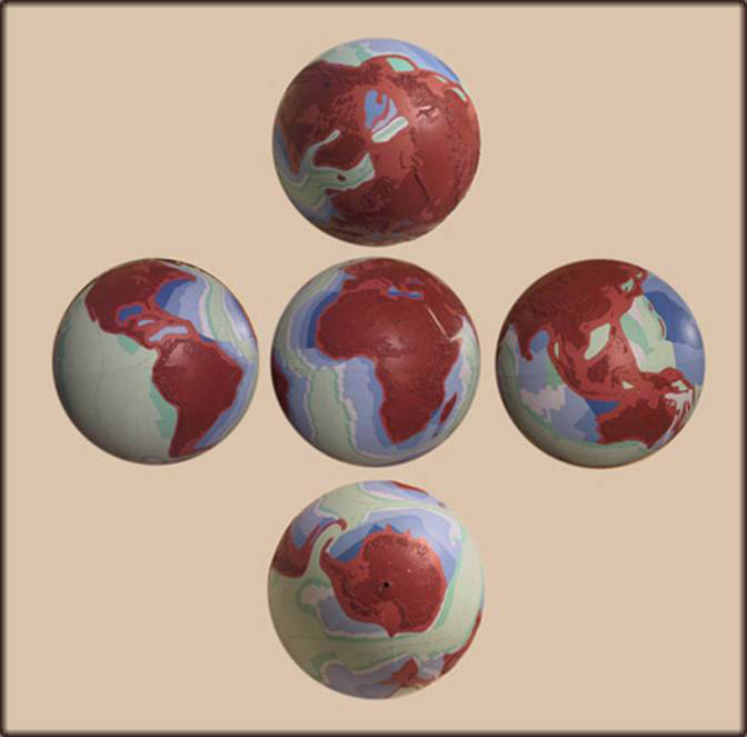
Present globe: Dark blue = Jurassic,
middle blue = lower Cretaceous,
light blue = Upper Cretaceous. White =
Paleocene, dark green = Eocene,
light green post-Eocene.
Where could a round continent on Planet Earth
have come from -- in a manner that satisfies all the requirements for a
Jurassic area budget as well as of isochrone maps and severance-tension
budgets? Indeed, we do have a roundish cavity shaped like
the 9, right next to the 9-shaped figure of Antarctica. Moreover,
my expanding balloon experiments have shown that it is quite natural,
initially, for a round patch of crust to be broken out of a spherical shell as
a result of expansion pressure that is being converted into horizontal surface
tension. Then, let us look at the “Ring of Fire” and at magnetic stripes in the
Pacific. They continue to give us the 9-shape of Antarctica,
expanding all the way up to our present day. And the Ring of Fire,
though considerably expanded over time, still outlines the initial scar from
along which Antarctica was torn, over time.
While at the north of the planet all the continents still are
together, they have broken open in the south like the blossom of a flower. So,
during the Eocene a major tectonic jolt set off the birth pangs by which the
Antarctic Plate began to slip from the Pacific womb. How was this possible in
relation to everything else? First, Australia snapped away from the
tip of South America and created there a soft bottom. Eventually it widened to
become the Antarctic Ocean -- for the Antarctic Plate to twist into. At
the same time Austral-Asia, like a sluggish and viscous rubber band, snapped
off and pulled northeastward. Northward was its initial global-circumferential
pull, but eastward lay a soft area that was being vacated by Antarctica.
Then, from the Tonga Ridge Australia ricocheted westward,
leaving behind a ridge and a trench, in order, then, to pinch the swirl
of Celebes in the west.
South America, being a larger continent, and with its crust being
still strong, did not “travel” the same distance
as Australia (Australia was yanked farther by the overstretched
crust -- and by the underground, that lay between it and Asia). South
America pulled away north-eastward, in the opposite direction and away
from Australia. South America then pushed against the
southeastern corner of North America and wedged that northern
continent westward, at some distance over the Pacific spreading rift -- which
therefore runs under California now. In that process, South America has
twisted Middle America northeastward. In addition, this same Eocene
event has pinched off a small Paleocene section of seafloor in
the Atlantic, along the Middle American latitudes.
A closing Thought
I have been told that my theory could not be valid because back
in 1979, already, I have placed the tip of South America into the Bight of
Australia -- based at the time merely on estimating continental contours. Yes,
indeed, I did not consult magnetic stripes until after the California
earthquake of 1994. But so what! One cannot disprove a contemporary theory by
the incomplete data and by hypotheses that lie in its prehistory. The
arrangements achieved by others -- including those that have Australia in the
North Pacific -- also were at their inception mere projections based on
continental contours -- lubricated here and there by a scientist’s creative
imagination.
Surely, all scientific theories, including mine, suffer from a
variety of growing pains and contain a great variety of weaknesses. Some of
these I already know, and I continue to weigh them against those that so far
have rendered alternate theories unacceptable for me. And if there are
weaknesses that I do not yet know about, I hope I will find them eventually.
Perhaps with your help I can be converted to a “majority” Expansionist view. It
is no fun to stand alone as a minority of one -- upon this ever-expanding
planet. A human being craves company and should be able to enjoy dialogue, now
and then. Life is short -- and yet, perhaps it is long enough.